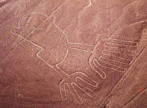
From the air, the lines etched in the floor of the desert were hard to see, like drawings left in the sun too long. As our pilot cut tight turns over a desert plateau in southern Peru, north of the town of Nasca, I could just make out a succession of beautifully crafted figures.
"Orca!" shouted Johny Isla, a Peruvian archaeologist, over the roar of the engine. He pointed down at the form of a killer whale. "¡Mono!" he said moments later, when the famous Nasca monkey came into view. “¡Colibrí!” The hummingbird.
In the Peruvian Desert, about 200 miles south of Lima, there lies a plain between the Inca and Nazca (sometimes also spelled Nasca) Valleys. Across this plain, in an area measuring 37 miles long and 1-mile wide, is an assortment of perfectly-straight lines, many running parallel, others intersecting, forming a grand geometric form. In and around the lines there are also trapezoidal zones, strange symbols, and pictures of birds and beasts all etched on a giant scale that can only be appreciated from the sky.
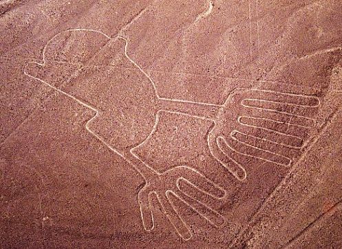
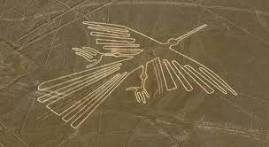
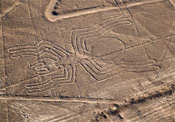
The figures come in two types: biomorphs and geoglyphs. The biomorphs are some 70 animal and plant figures that include a spider, hummingbird, monkey and a 1,000-foot-long pelican. The biomorphs are grouped together in one area on the plain. Some archaeologists believe they were constructed around 200 BC, about 500 years before the geoglyphs.
There are about 900 geoglyphs on the plain. Geoglyphs are geometric forms that include straight lines, triangles, spirals, circles and trapezoids. They are enormous in size. The longest straight line goes nine miles across the plain.
Though discovered by Peruvian archaeologist Toribio Mejia Xesspe who spotted them while hiking through the surrounding foothills in 1927, the forms are so difficult to see from the ground that they were not widely known until the 1930's when aircraft spotted them while surveying for water. The plain, crisscrossed, by these giant lines with many forming rectangles, has a striking resemblance to a modern airport. The Swiss writer, Erich von Daniken, even suggested they had been built for the convenience of ancient visitors from space to land their ships. As tempting as it might be to subscribe to this theory, the desert floor at Nazca is soft earth and loose stone, not tarmac, and would not support the landing wheels of either an aircraft or a flying saucer.
So why are the lines there? The American explorer Paul Kosok, who made his first visit to Nazca in the 1940s, suggested that the lines were astronomically significant and that the plain acted as a giant observatory. He called them "the largest astronomy book in the world." Gerald Hawkins, an American astronomer, tested this theory in 1968 by feeding the position of a sample of lines into a computer and having a program calculate how many lines coincided with an important astronomical event. Hawkins showed the number of lines that were astronomically significant were only about the same number that would be the result of pure chance. This makes it seem unlikely Nazca is an observatory.
Perhaps the best theory for the lines and symbols belongs to Tony Morrison, the English explorer. By researching the old folk ways of the people of the Andes mountains, Morrison discovered a tradition of wayside shrines linked by straight pathways. The faithful would move from shrine to shrine praying and meditating. Often the shrine was as simple as a small pile of stones. Morrison suggests that the lines at Nazca were similar in purpose and on a vast scale. The symbols may have also served as special enclosures for religious ceremonies.
How were they built? The lines were apparently made by brushing away the reddish, iron oxide covered pebbles that compose the desert surface and uncovering the white colored sand underneath. In most places wind, rain and erosion would quickly remove all traces of this within a few years. At Nazca, though, the lines have been preserved because it is such a windless, dry and isolated location.
A writer by the name of Jim Woodman believes that the lines and figures could not have been made without somebody in the air to direct the operations. "You simply can't see anything from ground level," states Woodman. "You can't appreciate any of it from anywhere except from above. You can't tell me the Nazca builders would have gone to the monumental efforts they did without ever being able to see it."
Woodman has proposed that ancient hot-air balloons were used to get an aerial view of the construction. To prove his hypothesis, Woodman constructed a balloon using materials that would have been available to the Nazca people. He was able to conduct a successful flight, though it only lasted two minutes.
Story continues below !
Most researchers are extremely skeptical of Woodman's conclusions, however, as they find little evidence in the remains left by the Nazca of any balloon construction or operation.
It is more likely that the Nazca people used simple surveying techniques in their work. Straight lines can be made easily for great distances with simple tools. Two wooden stakes placed as a straight line would be used to guide the placement of a third stake along the line. One person would sight along the first two stakes and instruct a second person in the placement of the new stake. This could be repeated as many times as needed to make an almost perfectly-straight line miles in length. Evidence that the line makers used this technique exists in the form of the remains of a few stakes found at the ends of some of the lines.
The symbols were probably made by drawing the desired figure at some reasonable size, then using a grid system to divide it up. The symbol could then be redrawn at full scale by recreating the grid on the ground and working on each individual square one at a time.
Recently two researchers, David Johnson and Steve Mabee, have advanced a theory that the geoglyphs may be related to water. The Nazca plain is one of the driest places on Earth, getting less than one inch of rain a year. Johnson, while looking for sources of water in the region, noticed that ancient aqueducts, called puquios, seemed to be connected with some of the lines. Johnson thinks that the shapes may be a giant map of the underground water sources traced on the land. Mabee is working to gather evidence that might confirm this theory.
Other scientists are more skeptical, but admit that in a region where finding water was vital to survival, there might well be some connection between the ceremonial purpose of the lines and water. Johan Reinhard, a cultural anthropologist with the National Geographic Society, found that villagers in Bolivia walk along a straight pathway to shrines while praying and dancing for rain. Something similar may have been done at the ancient Nazca lines.
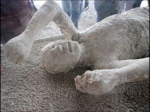
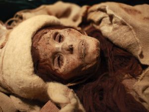
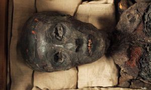
A recently discovered headless body suggests that human sacrifice was used by the Nazca people in religion ceremonies. "Human sacrifice and decapitation were part of powerful rituals that would have allayed fears by invoking the ancestors to ensure fertility and the continuation of Nasca society," wrote Christina Conlee of Texas State University in an article in Current Anthropology. "The decapitation of the La Tiza individual appears to have been part of a ritual associated with ensuring agricultural fertility and the continuation of life and rebirth of the community." The body is one of eight found in the Nazca area, buried seated with no head. A ceramic jar painted with an image of a head was found next to the remains. The head on the jar has a tree with eyes growing out of it, making it seem likely that the sacrifice was part of a fertility ceremony.
What was done with the heads of the victims? The Nazca were known to collect "Trophy Heads." The Nazca removed the brain and soft tissue from the skulls, sewed the lips closed with cactus spines and drilled a hole through the forehead to accommodate a loop of woven rope. The heads were then hung on the ropes for display. Originally these were considered to be war trophies collected from distant tribes, but recent DNA analysis shows that the heads came from the Nazca population itself, suggesting that the motive was religious in nature.
Other South American Lines and Figures
The lines at Nazca aren't the only landscape figures South America boasts. About 850 miles south of the plain is the largest human figure in the world laid out upon the side of Solitary Mountain in Chile. The Giant of Atacama stands 393 feet high and is surrounded by lines similar to those at Nazca.
Along the Pacific Coast in the foothills of the Andes Mountains is etched a figure resembling a giant candelabrum. Further south, Sierra Pintada, which means "the painted mountain" in Spanish, is covered with vast pictures including spirals, circles, warriors and a condor. Archaeologists speculate that these figures, clearly visible from the ground, served as guideposts for Inca traders.
Stretching across the Nazca plains like a giant map or blueprint left by ancient astronauts, lie the famous Nazca Lines of Peru. Peru is associated with the Inca Civilization.
The Nazca Lines, mysterious geoglyphs that span a vast swath of the rugged Peruvian desert, remain an engima. No one has proof as to who built them and what their function was. Since their discovery, the they have inspired fantastic explanations from ancient gods, a landing strip for returning aliens, a celestial calendar created by the ancient Nazca civilization -- putting the creation of the lines between 200 BC and 600 AD, used for rituals probably related to astronomy, to confirm the ayllus or clans who made up the population and to determine through ritual their economic functions held up by reciprocity and redistribution, or a map of underground water supplies.
There are also huge geoglyphs in Egypt, Malta, United States (Mississippi and California), Chile, Bolivia and in other countries. But the Nazca geoglyphs, because of their numbers, characteristics, dimensions and cultural continuity, were made and remade throughout the whole pre-hispanic period, forming a most impressive, as well as enigmatic, archeological group.
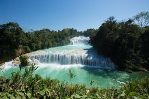
The Nazca Lines are located in the Nazca Desert, a high arid plateau that stretches between the towns of Nazca and Palpa on the pampa (a large flat area of southern Peru). The desolate plain of the Peruvian coast which comprises the Pampas of San Jose (Jumana), Socos, El Ingenio and others in the province of Nasca, is 400 Km. South of Lima, covers an area of approximately 450 km2, of sandy desert as well as the slopes of the contours of the Andes. They cover nearly 400 square miles of desert. Etched in the surface of the desert pampa sand about 300 hundred figures made of straight lines, geometric shapes most clearly visible from the air.
The Nazca plain is virtually unique for its ability to preserve the markings upon it, due to the combination of the climate (one of the driest on Earth, with only twenty minutes of rainfall per year) and the flat, stony ground which minimizes the effect of the wind at ground level. With no dust or sand to cover the plain, and little rain or wind to erode it, lines drawn here tend to stay drawn. These factors, combined with the existence of a lighter-colored subsoil beneath the desert crust, provide a vast writing pad that is ideally suited to the artist who wants to leave his mark for eternity.
The pebbles which cover the surface of the desert contain ferrous oxide. The exposure of centuries has given them a dark patina. When the gravel is removed, they contrast with the color underneath. In this way the lines were drawn as furrows of a lighter color, even though in some cases they became prints. In other cases, the stones defining the lines and drawings form small lateral humps of different sizes. Some drawings, especially the early ones, were made by removing the stones and gravel from their contours and in this way the figures stood out in high relief. The concentration and juxtaposition of the lines and drawings leave no doubt that they required intensive long-term labor as is demonstrated by the stylistic continuity of the designs, which clearly correspond to the different stages of cultural changes.
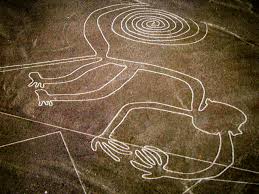
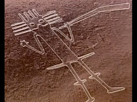
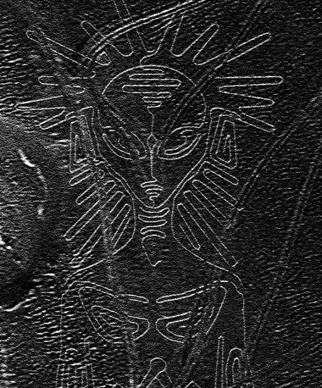
There appear to be various designs consisting of figures of animals, flowers and plants, objects, and anthropomorphic figures of colossal proportions made with well-defined lines. An example of this is the drawing of a weird being with two enormous hands, one normal and the other with only four fingers. Also represented are drawings of man-made objects such as yarn, looms and "tupus" (ornamental clasps). All these figures have well-defined entrances which could be used as paths or to allow people to line together along the conformations of the drawings. The anthropomorphic figures are relatively few and are situated on the slopes. The most well-known being is The Astronaut at 32m in length discovered by Maria Reiche in the 1960s.
Located in the arid Peruvian coastal plain, some 400 km south of Lima, the geoglyphs of Nasca and the pampas of Jumana cover about 450 km2 . These lines, which were scratched on the surface of the ground between 500 B.C. and A.D. 500, are among archaeology's greatest enigmas because of their quantity, nature, size and continuity. The geoglyphs depict living creatures, stylized plants and imaginary beings, as well as geometric figures several kilometres long. They are believed to have had ritual astronomical functions.
About 1500-2000 years ago the Nazca people inhabited this area. They might not be quite so well known today if it weren’t for the particular geological and climatic features of their homeland. Most people learn about the Nazca because of the famous Nazca lines etched in the desert between the Ingenio and Nazca river valleys. The desert formed an enormous drawing board for the Nazca upon which they etched huge lines, trapazoids, and animal figures by removing the dark colored surface stones and top soil to expose the lighter colored sand underneath. Spread out across several hundred sq kilometers (about 3-4x the size of Manhattan island) of the arid Peruvian desert, these drawings have been remarkably preserved. In any other climate, these drawings would have been obliterated in months, but the Nazca is one of the driest and most windless regions on earth. Much mystery surrounds these drawings, for their exact purpose and meaning remains unknown. How were they created so precisely? Some of the lines continue for kilometers on end only varying by a few degrees. For whom? And why? Even their dating is only somewhat certain, as it was approximated by the pottery shards found within the sands. It is possible of course that these lines were created before the Nazca, but it is difficult to ascertain the truth with no evidence to give us a clear and conclusive answer. As any find, or object from past civilizations is apt to do, these lines have drawn a lot of attention and speculation as to their use and reason for creation. It seems no one person can quite agree on how to understand the Nazca lines. Archaeologists and others have been trying to understand how and why these lines were formed for over 80 years. Anything from ancient foot race paths, and ceremonial walking, to alien runway’s have been suggested for the reason of the lines existence. It is necessary to explore all of these theories and to look at the recent and past research to see if one can come to any sort of conclusive picture behind the enigmatic lines in the desert.
As with all things from the past, it is nearly impossible to analze and interpret the findings with a completely objective and accurate viewpoint. Archaeologist’s, and other scientists project the ideas and values of the present upon the past. It is very difficult to escape our own cultural conditioning. This is the inherent problem within archaeology, especially, but they try to the best of their ability to understand the past with the tools they have.
Why would these ancient people make drawings so huge that they could not be appreciated from the ground, but only fully from above? Perhaps that was the point; they were intended for the eyes of the gods, as a sort of offering to them. The Nazcan’s were very religious, and much of their life revolved around the growing of crops. Their very lives depended on it, and no doubt they wanted to insure the good will of the gods. Or perhaps there was a more practical purport to the seemingly pointless lines in the desert?
One of the first people to study the lines was the American geologist Paul Kosok. He nazca-birdproposed an astronomical meaning to the lines, after he observed the sun setting exactly over the end of of the long single lines, on the winter solstice. The straight lines from “The largest astronomy book in the world’ as he proposed it, were intended to point astronomical events on the horizon. Keeping track of the position of the sun, moon, and other staars would have enabled the Nazca to predict when to plant and harvest their crops, as well as know when the rivers would have more water in them. By drawing upon the social developments he thought had taken place in that era, Kosok attributed the creation of the lines to a ‘power hungry-astronomer priest’ who used his knowledge and the lines as a form of rigid social control.
Marie Reiche continued the study after his death, and devoted over half her life to the measuring and mapping of the lines. She attributed a less practical application to the Nazca; they were intended as a sort of mental excersize to show off the Nazcan’s capability with geometry. Her extensive study, however, did not examine all the lines, and she came up with three different lenghts of measurement, 32.6m, 26.7, and 32.5 meters. Although possible that there is some correlation, it is probably unlikely that 3 such unrelated numbers have any real significance. Unlike the Egyptian Pyramids or Hindu temples, where their ‘sacred geometry’ repeats many auspicious numbers, such as pi, or 108.
The astronomical alignment hypothesis was basically disproved in 1968 by the astronomer Gerald Hawkins.He plotted the lines and analzyed them by computer to see if they corresponded to any constellations. Hawkins had studied Stonehenge years before and had developed a technique that enabled him to find an atronomical key to the site. Using this same technique, Hawkins found that the Nazca lines he studied were random, and did not correspond to any celestial bodies.
A point to note, for either of these view points, is that the scientists did not take into consideration which constellations where visable in South America, and whether they were different from those in the Northern Hemisphere. Also, little study has been done to discover which astronomical dates were important to the Nazcan’s to see if any of the events can be observed to correspond in some fashion to the lines. Without knowing what these people thought and held to be important, it is difficult to say that the monkey, or the spider, or any of the lines aligned astronomically with a particular star or group of stars. Especially as some formations are viewable only in one hemisphere and not the other.
The Cheque System
Another explanation posited for the lines is that they were a precursor to the Inca ceque system. The Inca had a tradition of imbuing power to features in the landscape. About 250 kilometers east of Nazca, is the Inca capital of Cuzco. It has four roadways, called suyus that lead out from the most remote areas of the kingdom. Spanish chroniclers documented that each of these roadways lay within 41 imaginary straight lines, or ceques, which all radiated outward from Coricancha, the temple in Cuzco which was considered the center of the Inca universe. Sacred places, called huacas, lay out on each of these ceques. Many of the ceques had the last huaca marking the subterrenean water sources of Cuzco’s irrigation system.